“Is New York Such a Labyrinth?”: Geospatial Mapping and The Age of Innocence
As Newland Archer attempts to instruct Ellen Olenska in the mores of Old New York, Ellen’s response merges approaches to cultural and geographic space. “Is New York such a labyrinth? I thought it so straight up and down—like Fifth Avenue. And with all the cross streets numbered!” (74). Ellen will learn that the social codes of Old New York as hardly as easy to navigate as the city streets, which she figures as a transparent, well-labeled
grid. Wharton’s The Age of Innocence (1920) was known for its fondly critical gaze at the Old New York and celebrated for its cultural, material, and geographic specificity. Wharton’s scrupulous re-creation of the spatial and material culture of Old New York, overlaid onto the story of the suppressed passion of Newland Archer and Ellen Olenska, made for a potent combination: the novel was a bestseller in its day, the subject of multiple theatrical and film adaptations, and the first by a woman to win the Pulitzer Prize.
 Wharton’s characterizations of New York as a “pyramid,” a “labyrinth,” and a “hieroglyphic,” figure the city as hierarchy, maze, and riddle, respectively. Inviting readings of the city itself as a complex cultural and social space, Wharton’s novel is ideal for this initial foray into the geospatial mapping of American literature. While many scholars have already explored modernist and nineteenth-century British cities through mapping tools, surprisingly little attention has been paid to the geographic spaces in the late nineteenth-century US, a period known for the vogue of literary regionalism or “local color.” It is my hope that this work will be the first in a collaborative project using mapping to explore the cultural and literal geographies of literary works of this period. I envision this group of maps as a scholarly and pedagogical tool that can help students engage with complex literary texts and develop a more nuanced understanding of the cultural moments of their production and reception.
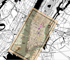
Through the map of Wharton’s New York that I created during my Humanities Writ Large year and accompanying documents and links, I hope to explore a number of questions related to spatiality in The Age of Innocence. For example, even the wealthiest characters in the novel experience significantly limited mobility; Wharton confines their movements to a few miles within Lower Manhattan. Geographic and social marginalization operate in tandem, making literal the distinction between center and periphery. Wharton also charts an emergent bohemianism, as artists, the lower middle-classes, and those critical of the dominant order remove themselves to the borders of the city. Tracking characters’ movements around New York, as the map invites users to do, invites discussion of the relation between spatial and social mobility. The affluent Newland Archer experiences little change in either physical location or class status over the course of his life, while Ellen Olenska returns to Paris and Archer’s son, Dallas, relocates to the West—only those outliers and members of the next generation experience significant social or geographic mobility. More than a chronicle of the 1%, The Age of Innocence punctures the myth of social mobility, emphasizing that class positions in the US are much more static than many would have it.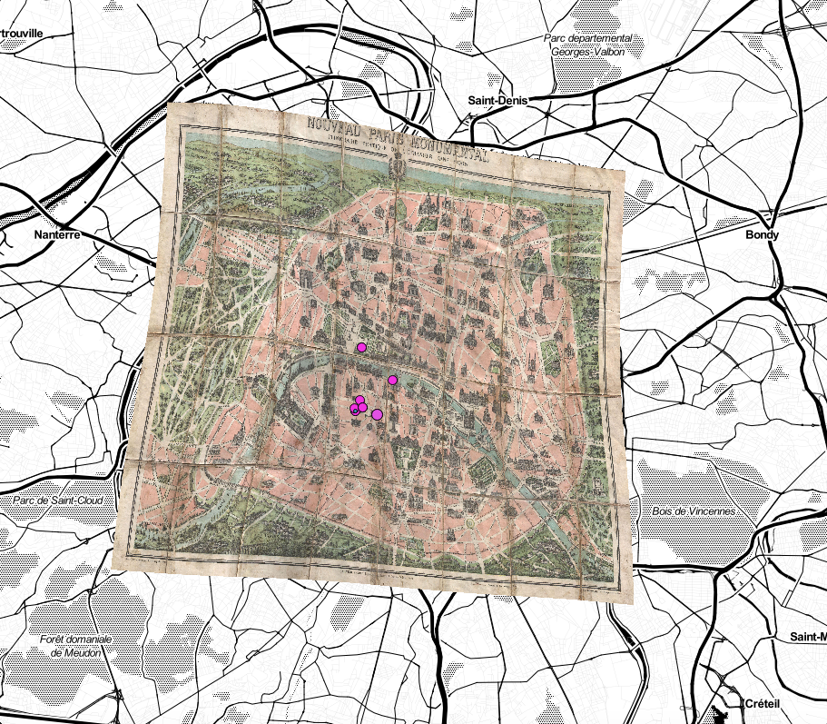
If the first two pedagogical elements of this map are literary and cultural, the third charts historical change. The near-fifty years between the publication of this novel and its setting saw dramatic changes in the demographics of lower Manhattan, of New York, and of the US more generally. Wharton wrote to an audience sensitive to these changes, particularly the effects of mass immigration. Links to sample census records from the neighborhoods alluded to in the novel will demonstrate the growing ethnic diversity of these locales; they should also point to income disparities within lower Manhattan, the home of Wharton’s elite. The historical data will provide the context that Wharton’s novel obscures, underscoring the fact by 1920, lower Manhattan was a largely immigrant and working-class enclave.
The visualization of The Age of Innocence this map offers aims to resonate with the lives of student users in a variety of ways. The wealth and social conservatism of Wharton’s characters often leads students to dismiss the qualities they–and we share with them. After exploring Wharton’s characters’ consumer habits, students might be encouraged to consider the sources of their objects. Does the paucity of American-made products in Wharton’s 1870s have something to tell us about the rush toward global consumerism today? Similarly, what does the closed community of old New York—its resistance to change and travel, its discomfort with diversity and controversy, its limited tolerance of outsiders—have to say about life on a small liberal arts college campus, especially in a state whose residents are unlikely to travel? Finally, what might students learn from examining historical change in a small geographical area, like Wharton’s lower Manhattan? It is my aim that this project will afford access to such questions, and students and faculty will be invited to generate assignments, questions, and reflections.
